Napa County
Planning, Building and Environmental Services Department Conservation Division
Attn: Kyra Purvis, Planner II
Email: kyra.pmvis@countyofnapa.org
1195 Third Street, Second Floor
Napa, CA 94599-3092
RE: Erosion Control Plan Application P14-00410, Le Colline Vineyards, Angwin, CA
Dear Ms. Purvis,
Please accept this letter as comments from the Napa County Land Trust, dba the Land Trust of Napa County (“Land Trust”). The Land Trust does not comment on development projects unless we are an abutter to the proposed development and believe that there is the potential for direct impacts to our property’s values. We are an adjacent landowner to the Le Colline Vineyards (“Le Colline”) property. The Land Trust’s Linda Falls Preserve (“Preserve”) shares its eastern boundary with Le Colline, starting at Deer Park Road and continuing south approximately 4,000 feet. Conn Creek is the boundary between the Preserve and Le Colline for approximately 1,300 feet.
The Land Trust acquired the 175-acre Preserve through a series of donations from three individual landowners, beginning 20 years ago. There is also a conservation easement over the Preserve, held by the Napa County Regional Park and Open Space District, completed in 2016. The intent of the land donors was to protect the property’s natural features and ecological values in perpetuity, including protection of over one mile of Conn Creek, a perennial tributary to the City of Napa’s municipal reservoir at Lake Hennessey. The Preserve has been a favorite hiking destination for many Napa County residents and visitors. It includes an actively-used trail network that provides recreational and scenic enjoyment within mixed hardwood-conifer forests and streamside areas, including the well-known Linda Falls waterfall.
In 2014, the Land Trust initiated a large-scale riparian habitat restoration project along Conn Creek within the Linda Falls Preserve under a Streambed Alteration Agreement (notification number 1600- 2014-0096-R3) with California Department of Fish and Wildlife. The Land Trust’s Conn Creek restoration plan is focused on invasive plant species removal (specifically targeting &tbus armeniact1s) and native plant revegetation efforts (Figure 1). The Land Trust’s objective is to thoroughly eradicate the R armeniacus invasion through this stretch of creek, while restoring native plant communities displaced by invasion. In order to meet these goals over the past five years, The Land Trust has hired and managed crews from the American Conservation Experience (“ACE”) annually. Thus far, ACE crews have spent a total of 2,789 project hours working towards these goals alongside Land Trust stewardship staff. In addition to conservation crews, the Land Tmst has organized and led 21 volunteer workdays to further the project. A total of 205 volunteers have contributed 581 hours over the past five years. The Land Trust has also received grants from the Napa County Wildlife Conservation Commission to support this project.
Since the project began, 4,882 native seedlings have been propagated and outplanted throughout the restoration area. All of the installed plants were propagated at a native plant nursery from seeds and cuttings collected directly from appropriate native riparian species growing within the Preserve.
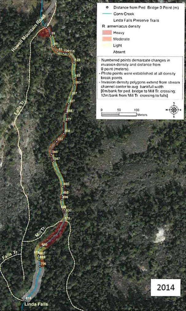
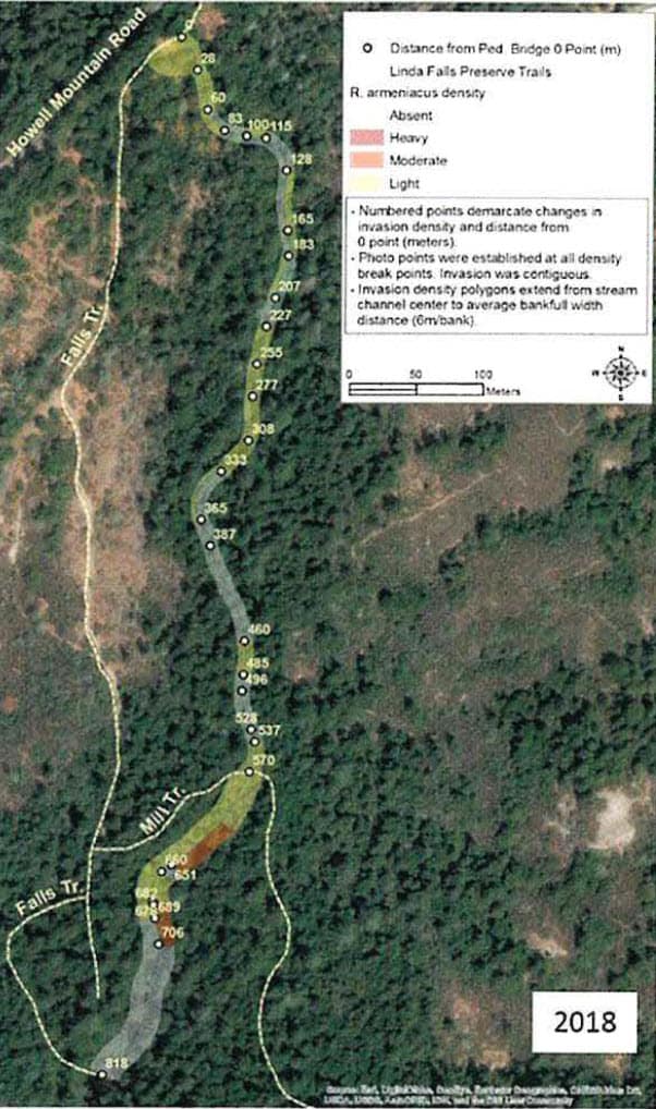
At the start of the project, the Land Trust developed and instituted an annual photo monitoring protocol in order to document restoration progress. Information collected through this monitoring practice is depicted in the enclosed invasion density maps representing 2014 and 2018 invasion levels (Figure 2). These maps demonstrate the significant decrease of R. armeniacus throughout the project area.
Prior to the start of the Conn Creek restoration project, the Land Trust enlisted the services of professional consulting herpetologist Jeff Alvarez of The Wildlife Project to conduct a herpetological assessment of Conn Creek within the project area. The primary objective of this assessment was to help ensure that restoration activities did not negatively impact special status species during project implementation. In the assessment, Mr. Alvarez identified the entire project area as “highly suitable for both foothill yellow-legged frog [(Rana b<))’lit)] and Coast Range newt (Taricha torosa torosa), which are both California Species of Concern.” The assessment report also makes the following management recommendations: avoid use of pesticides and fertilizers within 100 meters of Conn Creek; avoid allowing excessive vegetation debris to enter, be dumped, or placed into, or become mobilized during rain events and high water flows such that they can enter Conn Creek; if any special status reptile or amphibian is encountered, allow the animal to seek a natural refuge or to leave the immediate area under its own power. The nearest proposed vineyard block, A2, falls within 105 feet (or 30 meters) of Conn Creek.
In July 2015, the Land Trust observed foothill yellow-legged frog immediately adjacent to the Conn Creek channel while conducting restoration work. Staff immediately halted work and notified CDFW. In addition, the Land Trust submitted the observation to the California Natural Diversity Database through completion of a California Native Species Field Survey Form. The Land Trust also made CAL FIRE aware of this documented foothill yellow-legged frog occurrence in its letter of May 11, 2016 regarding the Le Colline Vineyard Conversion Project. However, the Draft EIR for Le Colline, in the table on Page 4.4-15, indicates that foothill yellow-legged frogs do not occur within the project site.
The Land Tmst has a vested interest in maintaining the integrity of the upper Conn Creek riparian corridor, based on the original intent of the land donors for protection of the Preserve, as well as the significant investments that have been made in the ongoing habitat restoration efforts. The Land Tmst has concerns that proposed vineyard development located closer than 300 feet from the riparian channel could impact priority species such as the yellow-legged frog, as well as ongoing native plant community restoration efforts through sedimentation and erosion caused by native vegetative cover removal and/or improper assessment of risk.
To that effect, the Land Trust prefers the alternatives presented in the plan. Review of both the Reduced Intensity or the Reduced Water Quality and Sensitive Habitat Protection Alternatives would better address our concerns for Conn Creek, both the portions at the shared Preserve-Le Colline boundary and its continuation through the Preserve and on downstream to Lake Hennessey.
Thank you for considering our comments on this project.
Sincerely,
The Land Trust of Napa County
Mike Pallaclini
Stewardship Program Manager

Lena Pollastro
Land Programs Manager
Figure 1. (A) American Conservation Experience (ACE) crew removes invasive species within the LTNC’s Conn Creek riparian project area on the Linda Falls Preserve. (B) ACE crew installs erosion control blanket along Conn Creek after removing invasive Himalayan blackberry, which dominated the site. (C) Native plants, propagated from material collected within the project area, staged for planting in previously invaded areas. (D) Land Trust volunteers plant native species in a previously invaded site.
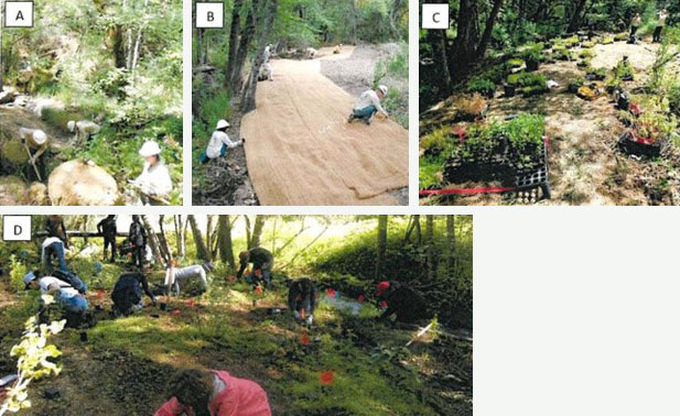
Figure 2. Himalayan Blackberry invasion density maps showing substantial reductions in invasion density between 2014 and 2018 accomplished through LTNC’s Conn Creek riparian habitat restoration project within the Linda Falls Preserve.